
SB10 WATCH-Scott Wiener styles himself an environmental legislator. In February 2017, the then-rookie state senator averred that “having good, well-planned, transit-oriented, compact housing…[is] one of the most critical things we can be doing to meet our climate goals.
It’s about driving less—about having to drive less.”
That rhetoric is hard to square with sprawl-inducing SB 10, which Wiener is carrying for its sponsor, California Yimby.
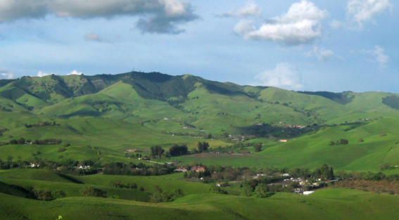
The Tassajara Valley would see more sprawl — and Wiener’s housing bill could encourage that.
SB 10 would encourage projects like the obscene Tassajara Parks development that the Contra Costa Board of Supervisors just approved on a 4-1 vote.
As Shomik Mukherjee reported in the Mercury News, Tassajara Parks will include 125 single-family houses on 30 privately owned acres in Tassajara Valley, an unincorporated area just east of Blackhawk “known for its natural splendor.” The county Planning Commission recommended that the Contra Costa supes reject the project. And the East Bay Municipal Utility District formally stated that it has inadequate water for the development.
Opponents included two supporters of SB 10, Greenbelt Alliance and the Yimby cell East Bay for Everyone.
“The Greenbelt Alliance,” wrote Mukherjee, “a Bay Area conservation advocacy group, hailed the Planning Commission’s decision as a ‘major win,’ warning that development outside the urban space boundary would expose any future housing to the risk of wildfires and contribute to greenhouse gas emissions.”
And even a local pro-housing group had reservations with the proposal. Kevin Burke of East Bay for Everyone, an urban planning-focused nonprofit, said new homes in the middle of a valley were not the solution to the region’s housing shortage.
“We don’t think that low-density expensive sprawl [the 125 homes are all market-rate; the developer is paying a total in-lieu fee of $486K—not a typo—to purchase land and build affordable housing in Contra Costa County] is going to help housing availability, reduce car dependency or help against climate change,” Burke said at the [Planning Commission] meeting. Instead, he suggested, developers should fill in pockets of space between existing buildings and towns, so that communities stay in closer proximity and new housing isn’t spread too far apart.
There’s a big disconnect between opposing Tassajara Parks and supporting SB 10. To see it, you have to decode the bill’s obfuscatory language.
Here’s how SB 10 begins:
SECTION 1.
Section 65913.5 is added to the Government Code, to read:
65913.5.
(a) (1) Notwithstanding any local restrictions on adopting zoning ordinances enacted by the jurisdiction that limit the legislative body’s ability to adopt zoning ordinances, including, subject to the requirements of paragraph (4) of subdivision (b), restrictions enacted by local initiative, a local government may adopt an ordinance to zone a parcel for up to 10 units of residential density per parcel, at a height specified by the local government in the ordinance, if the parcel is located in one of the following:
(A) A transit-rich area.
(B) An urban infill site.
“Transit-rich” and “urban infill” sound like Smart Growth boilerplate—until you dig into the details.
SB 10 defines “urban infill” as follows:
(3) “Urban infill site” means a site that satisfies all of the following:
(A) A site that is a legal parcel or parcels located in a city if, and only if, the city boundaries include some portion of either an urbanized area or urban cluster, as designated by the United States Census Bureau, or, for unincorporated areas, a legal parcel, or parcels wholly within the boundaries of an urbanized area or urban cluster, as designated by the United States Census Bureau.
(B) A site in which at least 75 percent of the perimeter of the site adjoins parcels that are developed with urban uses. For the purposes of this section, parcels that are only separated by a street or highway shall be considered to be adjoined.
(C) A site that is zoned for residential use or residential mixed-use development or has a general plan designation that allows residential use or a mix of residential and nonresidential uses, with at least two-thirds of the square footage of the development designated for residential use.
Like “urban infill,” “urban uses” and “urbanized area or urban cluster” evoke compact development.
But there’s nothing compact or for that matter urban about the definition of urban uses in the California Health and Safety Code:
“Urban uses” mean any residential, commercial, industrial, public institutional, transit or transportation passenger facility, or retail use, or any combination of those uses. [Section 53545.12(g)].
The association with compact development, along with any conventional understanding of urban, totally vanishes in light of the phrase “as designated by the United States Census Bureau.” The Bureau’s website says that the agency “identifies two types of urban areas”:
- Urbanized Areas (UAs) of 50,000 or more people; and
- Urban Clusters (UCs) of at least 2,500 and less than 50,000 people
In February, the Census Bureau proposed changing these designations, but as of now, the old designations remain.
Thanks to Nancy Skinner’s SB 330, “The Housing Crisis Act of 2019,” we have a pretty good idea of how many California cities are covered by the Census Bureau’s definitions. SB 330 applies to any city in an urbanized area or urban cluster, as defined by the Census Bureau, except cities that have a population of 5,000 or less and are not within an urbanized area.
The California Department of Housing and Community Development calculated that Skinner’s bill affects 445 of the state’s 482 cities and 141 “census-designated places” (CDPs) in 22 counties. To illustrate those numbers, HCD provided a handy interactive map (the key is the menu icon in the sidebar).
Since, unlike SB 330, SB 10 does not exempt cities with populations of 5,000 and less, I surmise that Wiener’s bill applies to even more locales—which is to say, almost every settled place in California, no matter how sparsely populated.
Back to Tassajara Parks: To accommodate Tassajara Parks, the Contra Costa Board of Supervisors extend the county’s Urban Limit Line to include the project site. On July 19, I sent an email to the county’s Department of Conservation and Development asking, “In light of that change, is that parcel now designated as either an “urbanized area” or an “urban cluster”?
The next day, Principal Planner Will Nelson replied:
The Contra Costa County General Plan refers to “urban” and “non-urban” land use designations. Urban designations are allowed only inside the Urban Limit Line (ULL). When the Board moved the ULL, they also changed the land use designation for a portion of the parcel from Agricultural Lands (AL, a non-urban designation) to Single-Family Residential High-Density (an urban designation). So, we would say that that portion has an urban designation. The remainder of the parcel was changed from AL to Parks and Recreation, another non-urban designation. This portion will be conveyed to the East Bay Regional Park District. During the public hearings it was occasionally stated that the land is currently open space, ostensibly due to its location outside the ULL. That is incorrect. The land is privately owned and was designated for agricultural use.
That appears to mean that SB 10 applies to Tassajara Parks and more to the point, to other projects like it.
How does Wiener reconcile SB 10’s invitation to sprawl with his professed commitment to transit-oriented, compact development?
(Zelda Bronstein reports on planning in the Bay Area for 48 Hills.)